-
Notifications
You must be signed in to change notification settings - Fork 44
Dealing with large scenes
Many applications require airborne laser scanning simulations with large scenes. Without careful design of these scenes, we can quickly be limited by memory.
Memory requirements increase with the number of primitives in the scene. A primitive may be a triangle of an OBJ or a voxel. There are different ways to lower the number of primitives, depending on the scene and the applications, which can also be combined.
How large your scene has to be and which parts of it require high resolution depends on your use case.
Limit the reconstructed scene to your area of interest (AOI). Your AOI may depend on your platform and its positions/trajectory and on your scanner and its range. A larger scene with objects of lower resolution may be required for an airborne laser scanning (ALS) simulation. For a terrestrial laser scanning (TLS) simulations, higher resolution models may be needed but in a smaller overall area. You may also vary the level of detail as a function of the distance from the scanner. Use high-resolution objects near the scanner, but low-poly models or voxel models further away.
Consider using more simple geometries, e.g.:
- Instead of a DTM/DEM in GeoTIFF format (regular grid cells), use adaptive TIN refinement (e.g. Mandlburger et al. 2008)
- If the terrain is not relevant of the extent of the scene is small, you may even use a simple ground plane.
- Low-poly tree models instead of detailed tree mesh models with many complex leaves
Hint: When retrieving geometries from online sources, search for "low poly".
Often, your OBJ object can be simplified, i.e., the amount of triangles can be reduced, without losing a lot of detail.
- In Blender, this can be done with the decimate modifier. A video guide can be found here. With BlenderGIS, also GeoTIFFs can be loaded into Blender, decimated and saved as OBJ meshes.
- Other possible tools to simplify your geometry include:
- Meshlab e.g. Simplification: Quadric Edge Collapse Decimation
- Simplygon
- 3d-geometry-simplify
- Skimp (not for free!)
- and more
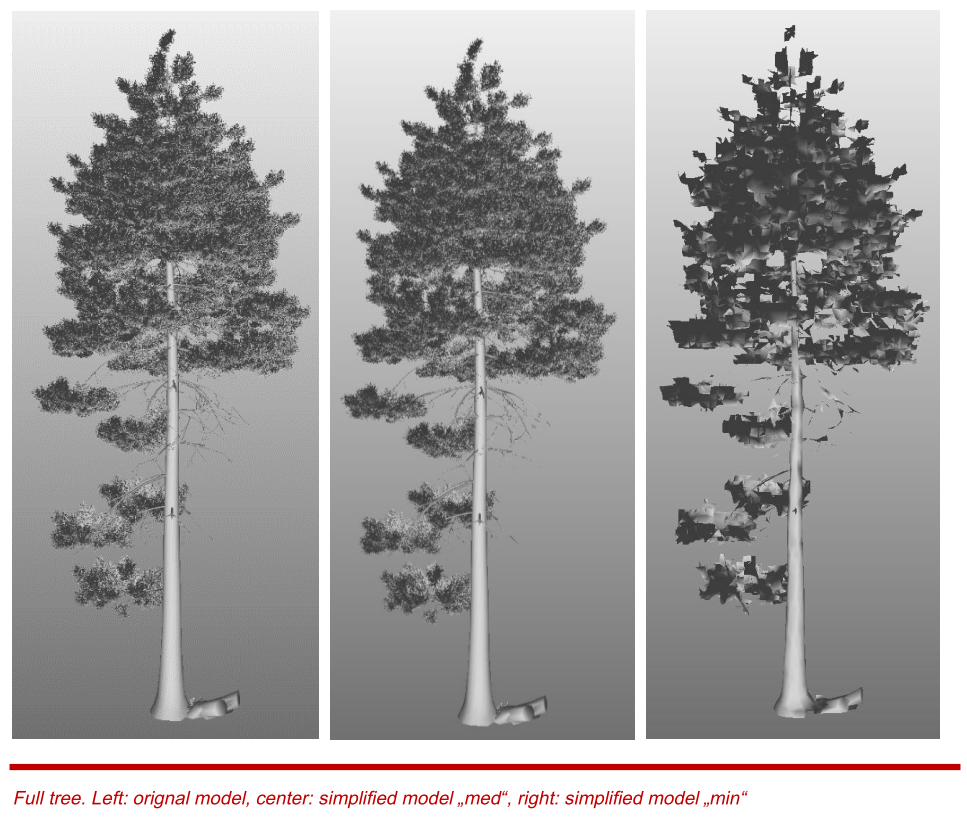
An investigation on a tree model showed that for certain use cases (here: flight plan validation), a reduction by a factor of 100 in the number of primitives and also in the file size has negligible impact on the resulting point distribution. A comparison of three tree models (6 Mio. triangles, 4 Mio. triangles, 50,000 triangles) is shown below. Read more here: tree-model-study.pdf

- Digital elevation models (DEMs; in GeoTIFF format) with larger grid size
DEMs are triangulated within HELIOS++ when building the scene. Thus, two triangles are built for each cell. A 10 times higher resolution (grid size) increases the number of triangles by a factor of 102.
| 0.5 m resolution | 5 m resolution | 10 m resolution | 25 m resolution |
|---|---|---|---|
 |
 |
 |
 |
 |
 |
 |
 |
| ~8,000,000 triangles | ~80,000 triangles | ~19,600 triangles | ~3,000 triangles |
DEM from: swissALTI3D, Open Government Data, Federal Office of Topography swisstopo
- Voxel model with larger voxel size


a) res: 5 cm, 191,688 voxels b) res: 25 cm, 6,385 voxels
- Tile your scene and then build the tiles and run the simulations on them separately. However, use overlapping tiles to avoid edge effects.